


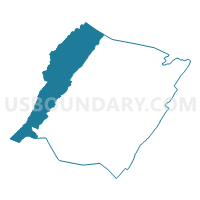
Mountain Grove Voting District, Bath County, Virginia
About
Outline

Summary
| Unique Area Identifier | 681133 |
| Name | Mountain Grove Voting District |
| County | Bath County |
| State | Virginia |
| Area (square miles) | 100.15 |
| Land Area (square miles) | 98.90 |
| Water Area (square miles) | 1.25 |
| % of Land Area | 98.76 |
| % of Water Area | 1.24 |
| Latitude of the Internal Point | 38.15952540 |
| Longtitude of the Internal Point | -79.86799260 |
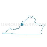
Maps

Graphs
Select a template below for downloading or customizing gragh for Mountain Grove Voting District, Bath County, Virginia


Neighbors
Neighoring Voting District (by Name) Neighboring Voting District on the Map
- Voting District 1, Greenbrier County, WV
- Voting District 21, Pocahontas County, WV
- Voting District 23, Pocahontas County, WV
- Callaghan Voting District, Alleghany County, VA
- Mill Gap Voting District, Highland County, VA
- Warm Springs Voting District, Bath County, VA
- Wilson's Mill Voting District, Highland County, VA
Top 10 Neighboring County Subdivision (by Population) Neighboring County Subdivision on the Map
- Eastern district, Greenbrier County, WV (11,601)
- Falling Spring district, Alleghany County, VA (2,489)
- Huntersville district, Pocahontas County, WV (1,135)
- Monterey district, Highland County, VA (1,101)
- Warm Springs district, Bath County, VA (822)
- Blue Grass district, Highland County, VA (536)
Top 10 Neighboring Unified School District (by Population) Neighboring Unified School District on the Map
- Greenbrier County School District, WV (35,480)
- Alleghany County Public Schools, VA (16,250)
- Pocahontas County School District, WV (8,719)
- Bath County Public Schools, VA (4,731)
- Highland County Public Schools, VA (2,321)
Top 10 Neighboring State Legislative District Lower Chamber (by Population) Neighboring State Legislative District Lower Chamber on the Map
- State House District 20, VA (76,800)
- State House District 12, VA (75,683)
- State House District 37, WV (38,124)
- State House District 28, WV (35,480)
Top 10 Neighboring State Legislative District Upper Chamber (by Population) Neighboring State Legislative District Upper Chamber on the Map
- State Senate District 24, VA (200,978)
- State Senate District 25, VA (194,804)
- State Senate District 15, WV (122,121)
- State Senate District 10, WV (106,143)
Top 10 Neighboring 111th Congressional District (by Population) Neighboring 111th Congressional District on the Map
Top 10 Neighboring Census Tract (by Population) Neighboring Census Tract on the Map
- Census Tract 9501, Greenbrier County, WV (5,283)
- Census Tract 9201, Bath County, VA (4,731)
- Census Tract 9602, Pocahontas County, WV (3,728)
- Census Tract 9701, Highland County, VA (2,321)
- Census Tract 803.01, Alleghany County, VA (1,905)
Top 10 Neighboring 5-Digit ZIP Code Tabulation Area (by Population) Neighboring 5-Digit ZIP Code Tabulation Area on the Map
- 24426, VA (14,329)
- 24986, WV (5,216)
- 24954, WV (3,514)
- 24445, VA (2,673)
- 24465, VA (1,382)
- 24484, VA (741)